
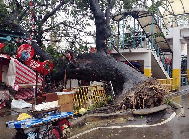
Typhoon Haiyan, locally called Yolanda, was like no other: trees were uprooted and GI sheet roofs were sent flying as strong winds bellowed and rains pummeled the central Philippines and provinces along its path on Friday (November 8). Haiyan entered the Philippines Wednesday.
With winds of 315 kph (195 mph), Haiyan was dubbed the strongest typhoon of the year in the world and one of the strongest that hit the Philippines since 1969. It was even compared to the infamous Typhoon Tip of October 1979, known for its peak wind gusts and massive size.
According to the Saturday (November 9) 6AM report issued by the National Disaster Risk Reduction and Management Council, there were over 100 confirmed deaths from the typhoon, including seven injured and four missing persons.
There was a report by the Civil Aviation Authority of the Philippines that some 100 dead individuals lie along the streets of Tacloban City, with the number expected to rise after teams visit the area. CAAP deputy chief John Andrews said only the runway of Tacloban City remain because the airport terminal was completely destroyed.

Some 792,000 Filipinos or 161,973 families were directly affected by the typhoon and were evacuated pre-emptively to centers in 37 provinces and 215 municipalities in nine regions, particularly the Visayas.
A satellite image by Eumetsat showed the massive size of Haiyan, which covered at least two thirds of the country as it passed along Central Visayas and is expected to go out of the Philippine area of Responsibility by Saturday afternoon at 2PM, four hours later from the earlier projection of 10AM after it slowed down.

Haiyan is the 24th typhoon to visit the country this year and agencies know better to prepare ahead, particularly with warnings that the typhoon with its winds that peaked at 315 kph was “off the charts.”
According to a report from Accuweather.com, Surigao City recorded over 10 inches of rainfall in under 12 hours. Surigao City is located south of the landfall point in Concepcion, Iloilo at 12NN of November 8.
This is the crowdsourced crisis map showing the affected regions as well as evacuation centers to guide rescue and relief teams.
Meanwhile, Haiyan spared Negros Oriental as it barreled across the country Friday.
Aside from the expected swelling of the Banica and other rivers as well as the toppling over of trees which cut off electric power in many parts of the island, there were hardly any reports of heavy damage to property. No casualties were also reported, although a fisherman from barangay Polo, Tanjay City, was reportedly swept away by strong currents towards Sumilon Island around noon Friday, when the storm was passing closest to Negros.
The still-unidentified fisherman was spotted by the security guard of the Sibulan port as his sailboat was hurtling by but they failed to stop him. He continued drifting towards the southern tip of Cebu island until he could no longer be seen, according to reports from the Negros Oriental Radio Amateurs of District 7, Inc. (NORAD-7).
Other than that, there seemed to be no excitement as rescuers sat glued to their TV screen at both the City and Provincial Risk Reduction and Management Council command centers, while others tried to catch on on their sleep.
By Friday afternoon, barely five hours after the critical period ended, Gov. Roel Degamo ordered the deactivation of the Provincial Command Center. Degamo said there was no continued need for the Provincial Command Center for Typhoon Yolanda as the critical stage had already passed and the localities have been able to effectively manage the situation.
The Governor, however, reminded key offices and agencies involved in emergency response such as the Philippine Army and the Philippine National Police, to remain on standby alert.
More than 5000 persons transferred to evacuation centers to wait for the Typhoon. Judith Chaves, one of the evacuees at the Amador Dagudag Memorial School in Looc, Dumaguete City, said she did not wait to be asked to evacuate. “We came here Thursday to seek shelter after we learned our lesson from Typhoon Pablo,” she said.
Over by the City Hall, Mayor Manuel Sagarbarria kept monitoring the weather condition in his office, working closely with Engr. Jose Chu, the head of the City Disaster Risk Reduction Management Council.
At the Provincial Capitol, Provincial DRRMC Executive Director Adrian Sedillo said that based on reports reaching them, the situation seemed normal even after the lapse of the critical period.
It was the second time in a week for the Provincial DRRMC to go on alert. The first being last Monday, after Tropical Depression Wilma threatened to make a direct hit on Dumaguete City. Wilma dissipated into a Low Pressure Area by Monday afternoon.
Text by Alex Rey Pal, Anna Valmero and PNEJ members.
Photo of uprooted tree by Philippine Red Cross Cebu, photo of relief goods center by Rhaydz Barcia, and photos of storm by Eumetsat and NASA.

Latest posts by EnviroNewsph (see all)
- Global fund aimed at protecting nature and accelerate investment in conservation, launched in Canada - August 25, 2023
- Why ‘loss and damage’ is the most bitterly fought-over issue at COP27 climate talks? - November 18, 2022
- U.S. hands over P2.3M in equipment and wildALERT system to PH to protect wildlife - December 16, 2020